Getting Started


Interested in researching historic military airfields?
This is a brief step-by-step guide on how to locate historic airfields, research them, and record them on the ground, and so make a valuable contribution to RAF100 and the “Defence Heritage Project”.
The aim is to record and study what remains of historic military airfield sites in Northern Ireland as part of the RAF100 centenary programme in 2018.
By recording and studying Northern Ireland’s historic airfields your findings will help advance our knowledge and appreciation of Defence Heritage in Northern Ireland.
By following the steps set out here, the research you'll carry out on an historic airfield will be useful if you wish to enter the RAF100 Schools Competition, see here [https://www.raf100schools.org.uk/competition] for more information.
Step 1: How to find an airfield site:
First, use our interactive map to find out more information about historic airfields in Northern Ireland (NI) that were used for military flying during the twentieth century.
For more information about a particular airfield, click on the numbered circle on the map and follow the links to find aerial photographs, maps and site descriptions for each airfield. We have provided a lot of information to help you start your airfield research, including files you can download. These files include modern-day aerial photographs for each airfield, plus a very valuable ‘site plan’ that shows that features of WWII airfields in a lot of detail. It is worth looking through all this information first, to see what materials we have gathered for you.
There are 28 historic airfield sites, mostly dating from the Second World War (WWII, 1939-1945), but some also date from the First World War (WWI, 1914-1918).
For each historic airfield site description, you will find a National Grid Reference (NGR), and this can be used to locate the site, either by using an Ordnance Survey map or by using a GPS/SatNav.
A quick way to get an NGR for a specific location is to use the Irish Grid Reference Finder tool.
PLEASE NOTE — All the airfield sites listed here can be viewed from public highways, but permission must always be obtained from local landowners before entering private land to take a closer look.
Step 2: What to look for at historic airfields:
Historic airfields used in the First World War (1914-18) have few visible signs left of them in the landscape but are still worth visiting and recording. To find out more about First World War airfields in Northern Ireland click here.
Historic airfields built during the Second World War (1939-45) have lots of features still to see, such as the remains of the airfield runways, and buildings used by the aircrews such as control towers, hangars, and huts for personnel.
One of the first things you should do, before visiting an airfield site to see what’s there, is study carefully the historical evidence for the airfield. This exercise is called a “Desk Top Study”.
First, to find out what already is known about the historic features at a particular airfield site, use the “Defence Heritage Project” interactive web-map.
This is an example (for Aldergrove, Co. Antrim) of what information you will find from the “Defence Heritage Project” web-map. Use the “Defence Heritage Categories” tab in the menu bar. If you click on the red dot (indicating an airfield) a pop-up box will give you a brief summary of the site:
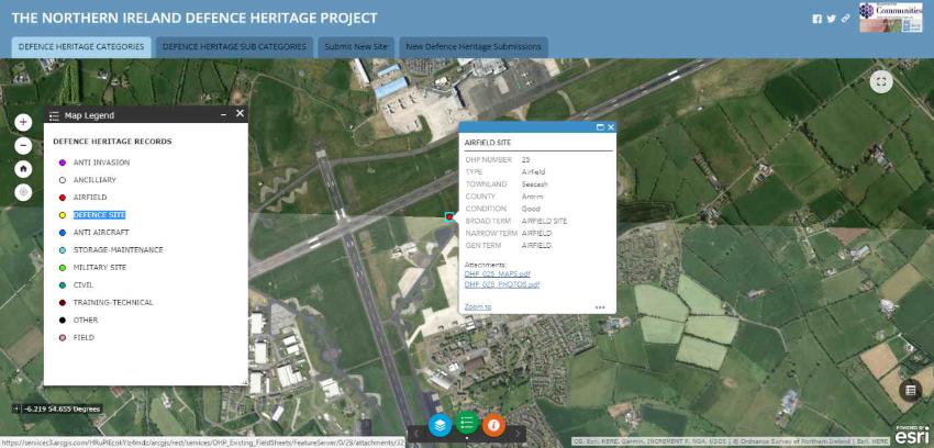
As this example shows, for some of our airfields, there is a lot still to see on the ground.
For 28 military airfields in Northern Ireland, we have collected examples of historic maps, modern aerial photographs and historic aerial photographs to help you with your research.
For each site, these sources are available for you to study by clicking on the airfield name on the RAF100 interactive map and then click an airfield number on the map or on the list below to access further information on the chosen airfield.
Using aerial photographs and historic maps make it possible to spot historic airfield features that have survived.
You’ll easily identify the former concrete runways for example, as here for the airfield at Ballykelly (Co. Derry/Londonderry):
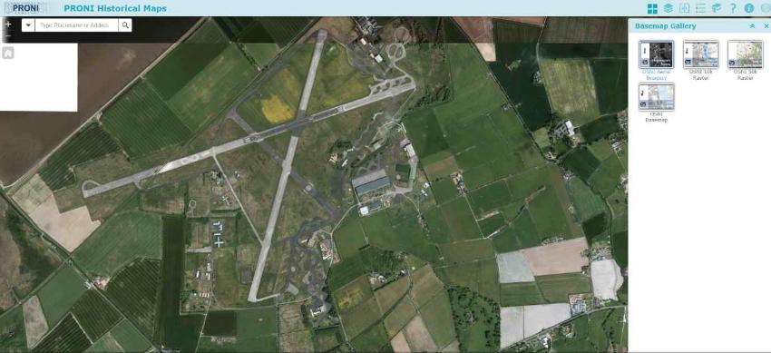
This aerial photograph is taken from the PRONI Historical Maps Viewer which you can access here.
The PRONI map viewer also has very detailed modern Ordnance Survey maps of airfield sites which are essential to help you navigate around the site and also for comparing with the aerial photograph to identify airfield features.
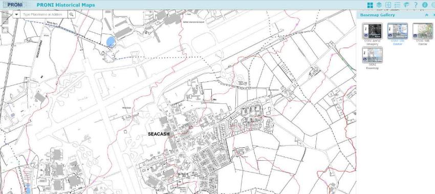
As an example, here is the modern Ordnance Survey map for Aldergrove (co. Antrim):
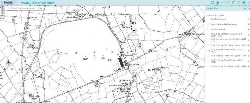
As well as modern Ordnance Survey mapping, the PRONI map-viewer also contains very useful historic Ordnance Survey maps which provide another source of information about historic airfields.
This is a historic Ordnance Survey 6” scale map of Aldergrove showing the site just after the First World War:
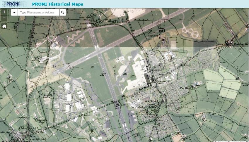
The historic maps can also be overlaid onto the modern aerial photographs and using the transparency tool the historic map and modern aerial photograph can be compared:
Information on how to use the PRONI Historical Map Viewer site is here.
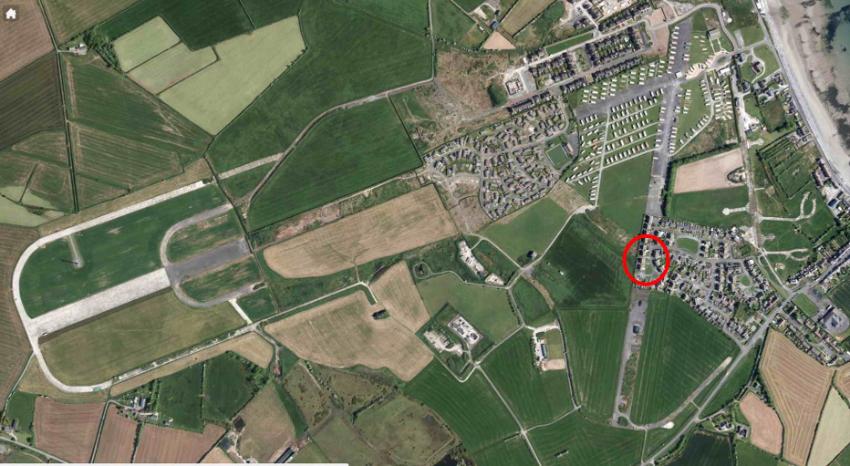
Most Second World War airfields were built with an A-plan of runways, like here at Ballyhalbert:
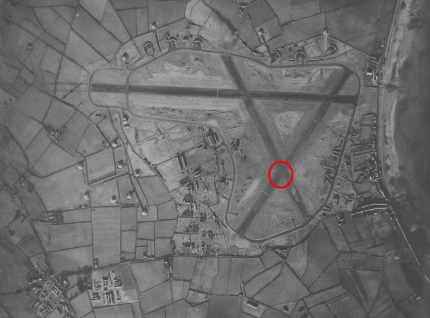
(15th January 1943 aerial photograph of Ballyhalbert (Co. Down), courtesy Ernie Cromie)
Our RAF100 airfield web-pages allow you to study examples of these aerial photographs and maps for the individual airfields, so before you visit an airfield take a close look at these.
Comparing modern and historic aerial photographs with each other, you will see how much of an old airfield has survived through to today. This is the modern aerial photograph of Ballyhalbert (Co. Down) from the PRONI Historical Maps Viewer:
Here, the intersection of the runways circled in red on the 1943 aerial photograph is the same point circled in red on the modern aerial photograph—what other features can you identify that have survived from the wartime airfield?
For WWII airfields, we have provided for you detailed historic “Site Plans”. These large-scale plans were originally drawn up during the war for planning and managing the airfields, and show the airfield’s features, such as runways, perimeter tracks, dispersal points, technical and domestic sites, and so on. The site plans are made available courtesy of the RAF Museum at Hendon. To access them for the airfield you are researching, just use the ‘Site Plan’ tab. Some airfields have more than one site plan..
Also, make sure you read about the airfield sites! Click on the Site Description tab for a brief summary of the airfield’s history. Good sources of information, via our “Useful Links”.
From doing your “Desk Top Study” you will now be able to draw up a list—an inventory—of features of the historic airfield that you want to take a closer look at on the ground by doing a “site visit”. The easiest way of drawing up an inventory is to compare the historic Site Plan of the airfield with a modern aerial photograph, and see if there are features still visible in the local landscape. By locating these features the next step is to investigate them on the ground through a ‘site visit’.
Step 3: What to do when you visit:
After you have completed your Desk Top Study of an airfield, the next step is to visit the site on the ground. This is called “Fieldwork” and includes looking in detail at what survives on the ground.
The “Site Recording Form”, accessible here, sets out what to record and how—this includes making a note of the feature you have identified, a building for example, and describing it and photographing it. It is essential that a full and detailed record is made, and the location is recorded using a National Grid Reference (NGR) or a Latitude-Longitude position, from your GPS or map.
To visit a site you have identified from your Desk Top Study, use the Irish National Grid Reference tool as with this example here for a building shown on the modern aerial photograph at Nutt’s Corner airfield (Co. Antrim):
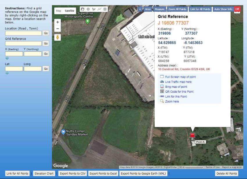
“Point A” is the building to be visited in the field, and the Lat-Long or NGR can be used by putting the coordinates into your GPS or SatNav and navigating to the site (making sure of course that you have gained permission to access the site, see here for more information).
The “Site Recording Form” is explained further in the “Defence Heritage Project Handbook”, accessible here, produced by the Historic Environment Division (HED) for Northern Ireland.
To help you identify airfield features “in the field”, here are some books to download for free - please visit “Useful Links”.
Step 4: After your visit:
We want your research to make a contribution to the RAF100 programme.
The research you have undertaken can be used to help you in developing your entry to the RAF100 Schools Competition. The prizes include:
- Invitations to RIAT, July 2018
- Invitations to the Guildhall Reception, 19 April 2018
- Places to the Horse guards event, 10 July 2018
- Places at Air-shows, July and Sept 2018
- Visits to BAE systems and RAF museums
- RAF100 commemorative items
- Meeting RAF personnel and veterans.
Another way of contributing to RAF100 as well as the Centenary of WWI in 2018 is to upload your completed “Site Recording Form” onto the “Defence Heritage Project” database, which you can do online by following this link and the instructions given there.
The information you have collected from your research will help protect historic airfields for future generations as well as sharing it with the wider community in Northern Ireland and beyond.