Defence Heritage project
By Lorraine Barry
The Defence Heritage Project (DHP) records archaeological sites and monuments in Northern Ireland that have had a defensive function. The project aims to publicise existing defence heritage records for Northern Ireland and also encourage public recording of new information on defence heritage. DHP began in 1997 and developed further in 2015 through the Living Legacies engagement centre working in partnership with Department of the Environment (NI) and the Geographical Information Science Research and Teaching Unit of the School of Geography, Archaeology & Paleoecology at Queen’s University Belfast.
As a result of this partnership, a user-friendly map based web application on defence heritage in Northern Ireland is now accessible at http://go.qub.ac.uk/DefenceHeritageNI and features an overview of DHP, an interactive map of previously recorded defence heritage sites throughout Northern Ireland, as provided by the Department of the Environment, and an insight into local sites of interest – for example on Boa Island, County Fermanagh and Ballyhalbert. It also features an online geoform (Recording Defence Structures) to facilitate the input and collection of further defence sites from community groups and members of the public with an interest in and local knowledge of historical defence in their local area.
The web resource has been created by Lorraine Barry, a geographical information scientist at Queen’s University, and is a great example of the power of ‘citizen science’, the ability to engage with members of the community using the public platform of the web map and geoform to enrich this research on defence heritage and to create a lasting and digital record of local memories, stories and defence locations within our local landscape. This crowd-sourced information is vital to ensure future generations are aware of the legacy of defence heritage within local communities and landscapes in Norther Ireland.
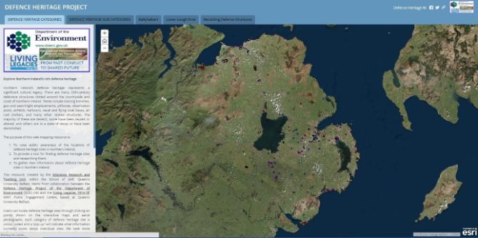
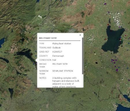 The online web-mapping application allows a user to click on any existing defence heritage record within Northern Ireland to view its recorded information. The resource can be used interactively to obtain an overview of defence sites throughout the province or to zoom to the location of particular local area sites. The modern aerial imagery allows users to identify sites and then explore them on the ground (subject to local access restrictions).
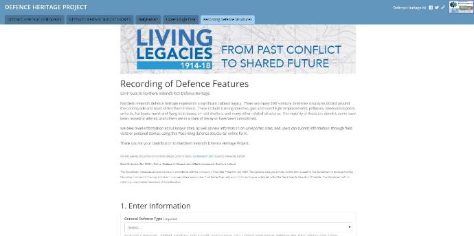
The tab on the web resource titled ‘Recording Defence Structures’ features the geoform where any visitor to the site can provide information relating to an unrecorded defence heritage site. The geoform links the input of information, personal stories and related documents to the location of the site. A user can interactively input information from the pull down menus on the geoform relating to the type of site, the period of defence and the condition of the site.
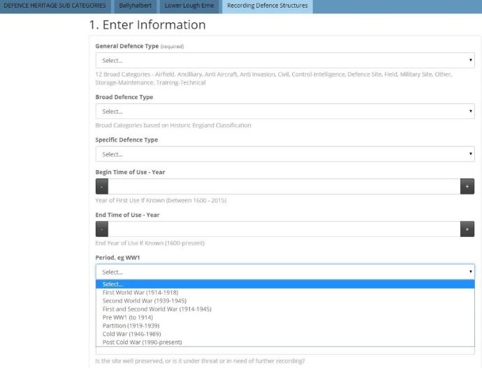
A user can upload site photographs of a defence heritage structure, scanned maps or historical documents, or any other relevant information. These documents, together with personal site stories, enrich the legacy and interest of the site and the overall defence heritage project. The end section of the geoform before submission of a new record allows a user to select the location of the site using either an aerial photography base-map or open street map. If a user is in-situ at the defence structure then the ‘locate me’ button can be used to determine the location from the user’s device (tablet, smartphone or computing device). If off-site, a user can use the zoom buttons or input a street name or address to locate the position of the site to be recorded.
Once a new record is submitted by an interested citizen he or she can delight in the knowledge that the contribution is part of the living legacy of defence heritage in Northern Ireland!
As part of the defence heritage project Emma McBride from the Department of the Environment (historic division) and Lorraine Barry from the GIS Research and Teaching Unit, School of GAP, Queen’s University along with members of the Lower Erne Heritage Group – Fred Ternan, Joan Nelson and Henry, took part in a ‘Below the Radar Recording’ for the BBC NI to publicise the richness of local defence heritage, to show the interest from community groups and to illustrate the use of the web resource. The programme is due to air on the 2nd May 2016. This programme will also be complemented by a variety of school based and community events to publicise the project and to encourage use of the web application.
 |
 |
 |