New ‘4D Somme’ Interactive Map of the Battlefields Launched
1st July 2016
Launch of ‘4D Somme’ to mark the Centenary of the First Day of the Battle of the Somme
A new interactive visualisation of the landscape of the Battle of the Somme has been launched by the Living Legacies centre to coincide with the centenary of the opening day of the battle on July 1st 1916.
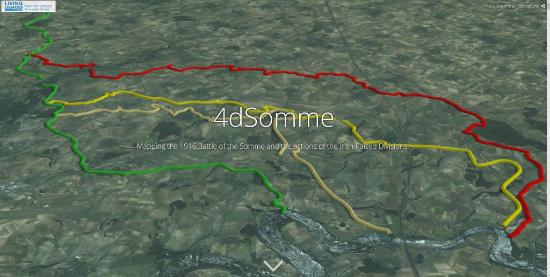
Called '4D Somme', the idea behind the visualisation is to show how the battlefield changed over the course of 1916, from July 1st to November 18th, as the British front-line slowly edged eastwards.
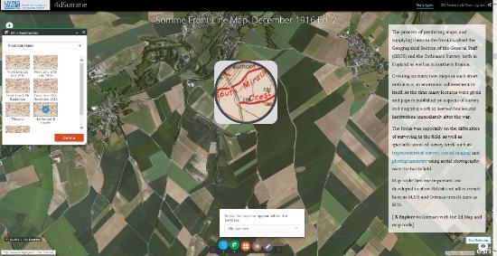
'4D Somme' uses the latest in Geographical Information Systems technologies to create interactive digital maps of the frontline by combining historic trench maps used at the time of the battle with modern day aerial imagery of the Somme landscape. It's aimed at a wide audience, from community groups, to school teachers and students, to battlefield visitors and tourists.
An AHRC funded programme linked to the centenary of WW1, in collaboration with the Heritage Lottery Fund (HLF), created five WW1 public engagement centres across the UK in 2014, and '4D Somme' results from the ongoing research of one of these engagement centres, 'Living Legacies 1914-18', based at Queen's University Belfast (http://www.livinglegacies1914-18.ac.uk/).
For many across the UK, and beyond, the Battle of the Somme is a key point in the commemoration of WW1, with much public and media interest in who fought where, yet visiting the battlefield is not possible for everyone. And so '4D Somme' is designed to allow users to explore the battlefield virtually, showing in detail the locations of trench systems as well as the front-line itself.
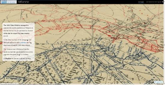
The focus of the '4D Somme' story-map is on the particular area of the Somme that saw action by battalions that were raised from Ireland, notably the 36th (Ulster) Division and 16th (Irish) Division.
Using ESRI GIS software, '4D Somme' is a web-mapping platform developed by a team at Queen's University Belfast in the School of Geography, Archaeology & Palaeoecology, including Conor Graham, a GIScientist, Rebecca Milligan, a PhD student, and historical geographer Professor Keith Lilley, Director of the AHRC Living Legacies centre at Queen's.
The trench maps for the Somme were continually updated and revised between July and November 1916, so we’ve been using our expertise in GIScience and landscape mapping to create an interactive set of maps, thanks to our collaborations with National Library of Scotland and the Bodleian Library at the University of Oxford. The aim of '4D Somme' is to use historic maps and modern technologies to open up new ways of understanding and exploring the momentous Battle of the Somme and its history and landscape, while at the same time creating a digital legacy of this critical point in the centenary of WW1.
The completion of '4D Somme' for the centenary of the first day of the Battle of the Somme will, we hope, help all those wishing to see the battlefield to be able to do so without the need to travel long distances to get to France, or indeed help visitors to the battlefield to orientate themselves before they go as well as enhance their experiences while they are there.
The '4D Somme' visualisation is live and free to use via this web-link:
go.qub.ac.uk/4dsomme
Top of Page

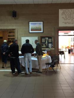 Living Legacies 1914-18 and the Somme Museum in County Down hosted a community event on Friday July 1st to commemorate the centenary of the opening of the Battle of the Somme on July 1st 1916.
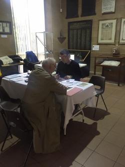 As well as bringing WW1 objects, the researchers also used new technologies to show how different types of trenches were created in the battlefields of France and Belgium. Conor Graham used an Augmented Reality Sandbox to show how trench warfare changed during the war, and how the landscape of the Somme battlefield affected how the battle was fought. Sophie Long, Keith Lilley, Tom Thorpe and Tim Bowman were also there to talk to visitors about the Somme through photographs and maps, including using ‘green screen technology’, while for those interested in seeing what landscapes were like in WW1, both at home and on the frontline at the Somme, Living Legacies ran a short film at the museum throughout the weekend.