
Project 6 - Mapping the Western Front
Locating lives on the Western Front: Online Mapping Resources for Researching the Western Front
By Keith Lilley
Many groups and individuals are interested in finding out where on the Western Front particular battalions or servicemen saw action.
There are two important and free online resources to help researchers to locate particular places and trenches using both historic and also modern mapping.
The following information is provided to assist those wishing to use these resources for their own research. The first part explains how to find map coordinates using the names that were given to trenches by those on the front line, while the second part below helps you to locate where these trenches lay, and how to find them on the ground.
1. Finding a place or trench name mentioned on diaries, letters, newspapers etc:
It may be that you have a diary or letter that tells you that a particular individual fought in such and such a trench, or near a particular village or town, in either France or Belgium.
To locate the position of the trench or settlement an online resource is available from McMaster University in Canada. It is free to use and accessed here: http://library.mcmaster.ca/maps/ww1/ndx5to40.htm
To search for a settlement or trench by name use the ‘Text Search using Place Name or Trench Name’ tool at the top of the page:
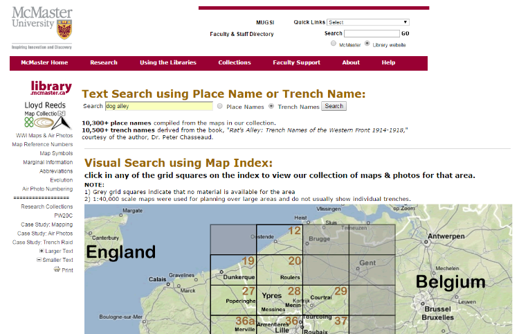
Entering the name, eg ‘Dog Alley’, in this case will produce a result in a pop-up box:
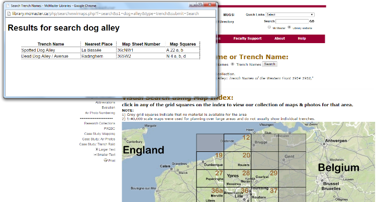
This will include a Map Sheet Number and a Map Square. Make a note of both of these.
For the 1:20,000 series of trench maps, the Map Sheet Number required is just the four number/letter sequence, ie 36SW, but for the 1:10,000 map series you will need the five digits, ie 36SW2.
Then go to another web-resource, created by the National Library of Scotland, which includes numerous First World War ‘trench maps’, of large scales, such as 1:10,000 and 1:20,000, which usually show trench systems and their names, so allowing us to locate the place or trench we’re searching for.
2. Locating a place or trench name mentioned on diaries, letters, newspapers etc
The next stage is to use the map number and map square and locate these on a trench map.
First go to: http://maps.nls.uk/geo/explore/
Which will open up like this:
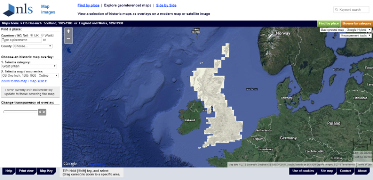
Then in the drop-down menu on the left side of the map window:
“Choose an historic map overlay:
1. Select a category:”
From the list click on: “Belgium/France, WWI Trench Maps”
Then in the drop-down menu below this choose the map sheet using the reference number already gained from the first search, in this case ‘Dead Dog Alley’ which has a map reference of 36SW:
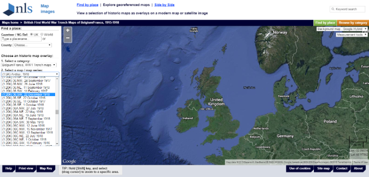
In this case there are two 36SW sheets available from NLS online at 1:20,000 scale. One of these maps was revised at the date given, in this case 14 February 1917, and the other was revised on 22 Dec 1918.
Select which map you wish to view and click “Zoom to this map / map series” which will then take you to this particular map sheet which will appear ‘overlaid’ onto a modern aerial photograph:
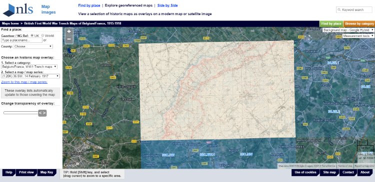
At this point we can take a closer look at the map using the Zoom tool, the + and – keys in the top left-hand corner of the map window. Also, the background modern aerial image can be changed using the drop-down menu on the top-right hand side.
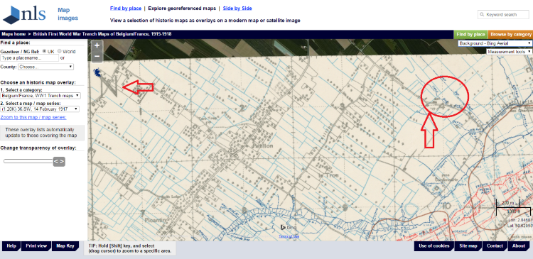
The letters on the map – here ‘N’ and ‘O’ and ‘T’ and ‘U’ – form part of the grid system used on British trench maps, and the small numbers are the grid squares, just like on a modern Ordnance Survey map where National Grid References are used.
A useful guide on how to use these maps, and how to work out the referencing system, is available from NLS at http://maps.nls.uk/ww1/trenches/info2.html
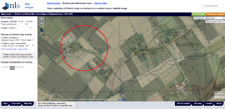
In the Dead Dog Alley trench example mentioned above, we need to go to square ‘N 4’, arrowed in the image below, and there we find the trench named on the map, circled in red here:
Now use the zoom tool to take a closer look:
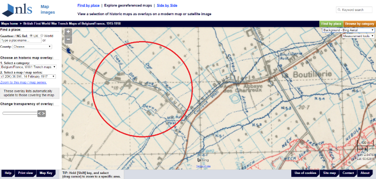
The trenches and other features marked in blue belong to British and allied forces, whereas those in red are German trench systems (visible on the right of the map) – ‘no man’s land’ is the area in between the two. To learn more about what the trench maps show see:
http://geo.nls.uk/mapdata3/trench/key/openlayers.html
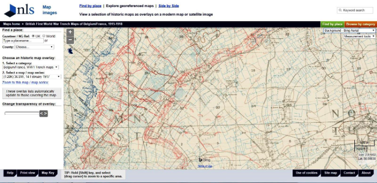
To view the same area as it is today simply use the ‘transparency tool’, which is on the left of the map window, a ‘slider bar’ that allows us to ‘see through’ the trench map to the modern landscape shown on the aerial photograph. 100% will show only the modern landscape, 0% only the trench map, so around 50% (ie sliding to half way) will show a bit of both:
Here we see what the landscape of Dead Dog Alley looks like today, a landscape of farms and fields. The details of the trench map are still just visible but so too is the modern aerial photograph, allowing us to relate one to the other, to juxtapose the wartime landscape with the modern landscape.
If you wish to visit the site on the ground, and have access to a Sat Nav system, simply make a note of the latitude and longitude coordinates (in decimal degrees) shown on the bottom right-hand corner, you’ll need to ‘hover’ the cursor (arrow) over the trench to get the right coordinate position, in this case
Long 2.84559
Lat 50.63052
Enter these coordinates into your Sat Nav or GPS and use the ‘go to’ function, and then the device will navigate you to the correct location.
You may wish to take a copy of the map with you to look at, and this can be done using the print view option at the bottom of the page (observe the copyright instructions).
An alternative approach, to find a particular map sheet, is to use the index sheets at
http://maps.nls.uk/ww1/trenches/index.html
which will take you here:
http://maps.nls.uk/geo/find/#zoom=8&lat=50.05084&lon=2.83987&layers=60
and by clicking on the red areas (the map sheets available) you’ll see the results listed on the right hand side.
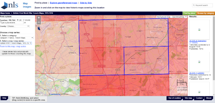
This is fine if you know which sheet you are interested in viewing, just click on it and it will then appear.
Finally, please note that the NLS map viewer does not have all trench maps, just those so far scanned and rectified. These resources are provided by external parties not by Living Legacies.
Living Legacies team members have particular interests in mapping and landscapes of the First World War, see
http://www.livinglegacies1914-18.ac.uk/MaterialCulturesandArchaeology/
and
http://www.livinglegacies1914-18.ac.uk/DigitalTechnologiesandDigitisation/
If you have ideas for a community research project that uses these online mapping tools please do get in touch with us.
Have fun!