Project 7 - 4D Somme, Mapping the 1916 Battle of the Somme and the actions of the Irish Raised Divisions.
The Battle of the Somme was one of the largest battles that occurred during World War I. It took place near the River Somme in France from 1st July 1916 to 18th November 1916. Attacks along the Somme lines saw some of the largest actions of the Irish Raised Divisions (36th Ulster & 16th Irish) during the battle.
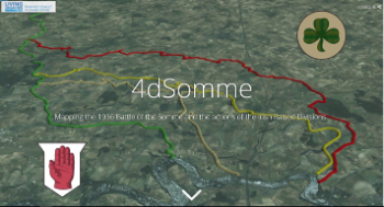 By using historic battle field maps of the time and modern Geographical Information Systems (GIS), we can help understand the key events of the Irish raised divisions, the following months of the Somme campaign, and help discover evidence of the battle in the modern landscape.
Developed by the GIS Research & Teaching Unit for the The Living Legacies Engagement Centre at the School Of Geography, Archaeology and Paleoecology, Queen's University Belfast.